| |


Croatia open 2012
| Competition name | Croatia open 2012 |
| Start date | 20120724 |
| End date | 20120729 |
| Country | Croatia |
| Race type | International |
| Nearest place or city | Lokve, Krk, Sunger, Delnice |
| Club/organizer | OK Ris Delnice |
| Region of country | Primorsko-Goranska region |
| Number of competition days | 5 |
| Expected number of runners | 1000 |
| URL for event homepage | [Link] |
| Get list of related events: | - Within 100 kilometers and +/-14 days - Within 500 kilometers and +/-14 days - Within 500 kilometers any time - All events within +/-14 days |
| Corrections | Make corrections for this event  |
| URL for invitation | [Link] |
| URL for video | [Link] |
| Contact email address | |
| Contact phone number | +385981718376 |
| Contact postal address | Ivica Urbanc, Stjepana Radića 1, 51300 Delnice, Croatia |
| Max distance from eventcentre to competitions | 65 km |
| Latest entry date | 1st July 2012 |
| Entry fee (Euro) | 6-16 (depending on category and entry time) |
| Event description | Enough with boring terrains, easy courses and cheap advertisement! Croatia open 2012 will set out new high standards for all of you! 6 days, 5 stages, 4 different types of terrain, 5 giant training areas on altitude from 0-1200m asl with more than 20 sq km of mapped area, sunny weather and charming Croats! |
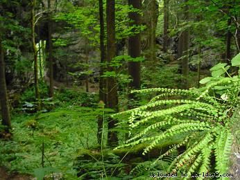
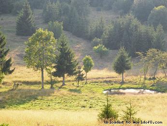
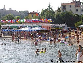
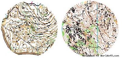
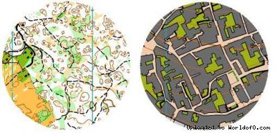
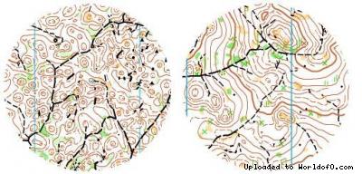
| Terrain description | First stage - extreme karst area in park-forest "Golubinjak" - primeval forest never touched by human hand. Second stage - urban, old town Krk and it´s Mediterranean surrounding with pine trees. Third stage - mixed scandinavian (flat) and hard karst (hilly) area Fourth stage - mixed continentall with steep slopes and scandinavian type of terrain Fifth - scandinavian (extremly flat) terrain ALL MAPS WILL BE MADE WITH LIDAR BASEMAPS. |
| Training possibilities | We will provide you several training maps on altitude from 0 m to 1200 m. Maps are drawn mainly by well known Czech, Ukrainian and Slovenian mapmakers providing you high drawing standards in tehnicly quite demanding surrounding on both urban and forest area. In region Gorski kotar we are offering you training areas on karst, continentall and alpine type of terrain while in Kvarner region we will offer you sprint training maps on Mediterranean terrains. |
| Holiday activities,nature,hiking etc. | Beside hiking, canoeing or cycling in highlands (we have plenty of mountain peaks higher than 1400 m) you can try out water-skiing, diving, swimming, bungee jumping and many other activities in our Adriatic coast. 500 m from finish area for 1st stage one of the biggest Croatian caves "Lokvarka" is located. Close to finish of second stage you may visit many museums and art galleries. |
| URL for results | [Link] |
| URL for map with course | [Link] |
| URL for photos from event | [Link] |
| URL for full race report | [Link] |
| Add to your calendar | 
 |
Map samples
Terrain and scenery images