| |


HSH Vysočina Cup
| Competition name | HSH Vysočina Cup |
| Start date | 20110714 |
| End date | 20110717 |
| Country | Czech Republic |
| Race type | International |
| Nearest place or city | Čachnov |
| Club/organizer | SK OB Chrast |
| Region of country | Bohemian-Moravian Highland |
| Number of competition days | 3 + night race on Thursday not included into three-day event |
| Expected number of runners | 1000 |
| WRE event? | No |
| URL for event homepage | [Link] |
| Get list of related events: | - Within 100 kilometers and +/-14 days - Within 500 kilometers and +/-14 days - Within 500 kilometers any time - All events within +/-14 days |
| Corrections | Make corrections for this event  |
| URL for invitation | [Link] |
| Contact email address | |
| Contact phone number | 00420608951177 |
| Max distance from eventcentre to competitions | max 1,5 km, night race 4km |
| Event description | Traditional (18th volume) summer three-day event in the middle of the Czech Republic. The event is organized by leading local club SK OB Chrast, succesful organizer of various O-events (HSH Vysočina Cup, Czech ultralong championship 2009, Czech relay league (2009,2011)). Each year, we are trying to prepare summer event for everybody - families with small children (kindergarden during the race included), runners hungry for success in demanding terrains or hobby runners taking O-events mainly as cultural experience. |
| Terrain description | Mildly hilly terrain typical for this region (Highlands) with a lot of variations, many water ditches and vegetation details in the altitude of 630740 m. Recent events in the nearby forests - JWOC 2001 (middle), Czech ultralong championship (2009). |
| Training possibilities | Map BOROVSKÝ LES from 2007, scale 1:10 000. The distance from the event centre is 4.7 km by bike, 8.5 km by car. Training controls available. Maps can be purchased at the registry office for 10 CZK /piece. Other possibilities of map-training are under request, club SK OB Chrast owns variety of maps within the region. |
| Add to your calendar | 
 |
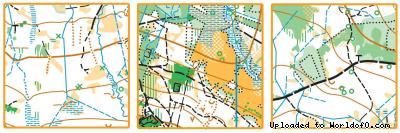
Map samples