| |


XXXII Ilvesteade
| Competition name | XXXII Ilvesteade |
| Start date | 20100709 |
| End date | 20100711 |
| Country | Estonia |
| Race type | International |
| Nearest place or city | Valga |
| Club/organizer | OC Ilves |
| Region of country | Southern Estonia |
| Number of competition days | 3 |
| Expected number of runners | 500 |
| WRE event? | No |
| URL for event homepage | [Link] |
| Get list of related events: | - Within 100 kilometers and +/-14 days - Within 500 kilometers and +/-14 days - Within 500 kilometers any time - All events within +/-14 days |
| Corrections | Make corrections for this event  |
| URL for invitation | [Link] |
| Contact email address | |
| Contact phone number | +3725040127 |
| Contact postal address | P.O. BOX 161, 50002, Tartu, Estonia |
| Max distance from eventcentre to competitions | 5km |
| Latest entry date | 28.06.2010 |
| Event description | OC Ilves welcomes you in the 32nd traditional midsummer 3-day orienteering-relay in the best terrains of South-Estonia. As last year we will start with great mass start in the first competition day, for all legs together. The result of the day results by summation of the times of three legs. On the main courses, there are also junior (N21Jun, M21Jun) and senior (N21Vet, M21Vet) groups separately accounted. Besides the main competition, there are Youth Ilves (NM10-14), Senior Ilves (NM51+) and Mini-Ilves competitions. |
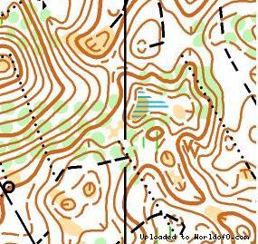
| Terrain description | Kantsi: Map scale 1:10000, contour interval 2,55 m. Mapper: K. Kalm. Previous map: No.8806. Database of Estonian o-maps: www.orienteerumine.ee. Terrain: Sandy pine grove with variable landforms. Runnability from good to very good. Dense network of tracks and paths; small marshes. Height differences up to 35 m. Oore: Map scale 1:10000, contour interval 2,5 m. Mapper: M.Oras. Previous map: No.8817. Terrain: Moderately hilly and variable landforms. Runnability from good to very good. Dense network of tracks and paths. Height differences up to 35 m. |
| Add to your calendar | 
 |
Map samples